2016.08.31:冥王星のメタンの雪と地表の成り立ち [NASA]
久々にNASAの探査機ニューホライズンズから新記事掲載が2件。
2件目は、冥王星の山に冠雪として積もっているメタンの雪と、地表に刻まれた谷についての記事です。
今までは、冥王星の目に見えていた部分についての情報でしたが、今後は、暗いところで十分に解析をしてなかったところに、何か発見があるかもしれないと伝えています。
NASA発表記事全文はこちら:冥王星のメタンの雪と地表の成り立ち
アンチエイジングプラス30パッチ (Anti-Aging Plus) 【パッチMD社製】
記事全文
[NASA記事掲載日]:Aug. 31, 2016
[NASA記事名]:Pluto’s Methane Snowcaps on the Edge of Darkness
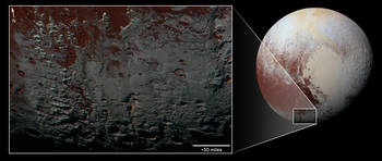
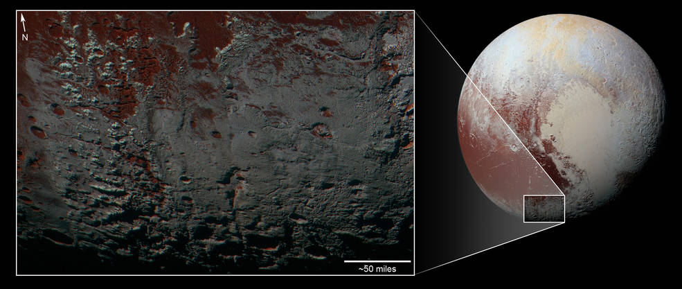
The southernmost part of Pluto that NASA’s New Horizons spacecraft could “see” during closest approach in July 2015 contains a range of fascinating geological features, and offers clues into what might lurk in the regions shrouded in darkness during the flyby.
NASAの探査機ニューホライズンズが、2015年7月の冥王星最接近時に「見る」ことがでた冥王星の最南端は、魅力的な地形の特徴があり、冥王星を通過した時には、暗い影に覆われていたが故に気が付かなかったものに対する、手がかりを与えてくれるかもしれません。
The area shown above is south of Pluto’s dark equatorial band informally named Cthulhu Regio, and southwest of the vast nitrogen ice plains informally named Sputnik Planum or Sputnik Planitia, as the mission team recently redesignated the area to more accurately reflect the low elevation of the plains. North is at the top; in the western portion of the image, a chain of bright mountains extends north into Cthulhu Regio. The mountains reveal themselves as snowcapped—something hauntingly familiar from our Earthbased experience. But New Horizons compositional data indicate the bright snowcap material covering these mountains isn’t water, but atmospheric methane that has condensed as frost onto these surfaces at high elevation. Between some mountains are sharply cut valleys – indicated by the white arrows below. These valleys are each a few miles across and tens of miles long.
上の図で、冥王星の暗い赤道地帯の非公式名称クトゥルフレジオという地域と、非公式名称スプートニク平面またはスプートニク平原の広大な窒素氷の平原の南西部の地域に対し、ミッションチームは、より正確に低い平野の標高を反映して、領域を再定義しました。上の方角が北になります;画像の西側部分で、明るい山の連なりが北側のクトゥルフレジオへ延びています。山々は雪の冠雪があることから全貌がよくわかり、地球でもよく目にする風景でもあることから何かしらの親しみを覚えます。しかし、ニューホライズンズの組成データを見ると、これらの山々を覆っている明るい冠雪は、水からできている物質ではなく、高高度で霜のように山の表面におりて固まった大気中のメタンであることを示しています。いくつかの山々の間は、急峻な谷となっています-下の図で白い矢印で示しました。これらの谷はそれぞれが数マイルの深さで、数十マイルの長さです。
A similar valley system in the expansive plains to the east (blue arrows) appears to be branched, with smaller valleys leading into it. New Horizons scientists think flowing nitrogen ice that once covered this area — perhaps when the ice in Sputnik was at a higher elevation — may have formed these valleys. The area is also marked by irregularly shaped, flat-floored depressions (green arrows) that can reach more than 50 miles (80 kilometers) across and almost 2 miles (3 kilometers) deep. The great widths and depths of these depressions suggest that they may have formed when the surface collapsed, rather than through the sublimation of ice into the atmosphere.
同じような谷が、小さな谷を伴って、広大な平野の東側(青色の矢印)で枝分かれするように見えています。ニューホライズンズの科学者たちは、かつて地表を覆っていた窒素の氷が流れた跡ではないかと考えています。おそらくスプートニクの氷は高い位置にあり、流れていった跡が、この谷を形作ったのではないかということです。この地帯は、不規則に急峻で、平坦な底部にはくぼみ(緑色の矢印)があり、全体で50マイル(80キロ)以上の長さと、ほぼ2マイル(3キロ)に達っする深さがあります。これらのくぼみの巨大な幅と深さは、気中へ氷が昇華せずに、地表で崩壊した時に形成されたのではないかという示唆をしています。
Credits: NASA/JHUAPL/SwRI
Last Updated: Sept. 1, 2016
Editor: Tricia Talbert
レチンAジェネリック0.1%(Acnelyse)
スポンサーリンク
2件目は、冥王星の山に冠雪として積もっているメタンの雪と、地表に刻まれた谷についての記事です。
今までは、冥王星の目に見えていた部分についての情報でしたが、今後は、暗いところで十分に解析をしてなかったところに、何か発見があるかもしれないと伝えています。
NASA発表記事全文はこちら:冥王星のメタンの雪と地表の成り立ち
アンチエイジングプラス30パッチ (Anti-Aging Plus) 【パッチMD社製】
記事全文
[NASA記事掲載日]:Aug. 31, 2016
[NASA記事名]:Pluto’s Methane Snowcaps on the Edge of Darkness
The southernmost part of Pluto that NASA’s New Horizons spacecraft could “see” during closest approach in July 2015 contains a range of fascinating geological features, and offers clues into what might lurk in the regions shrouded in darkness during the flyby.
NASAの探査機ニューホライズンズが、2015年7月の冥王星最接近時に「見る」ことがでた冥王星の最南端は、魅力的な地形の特徴があり、冥王星を通過した時には、暗い影に覆われていたが故に気が付かなかったものに対する、手がかりを与えてくれるかもしれません。
The area shown above is south of Pluto’s dark equatorial band informally named Cthulhu Regio, and southwest of the vast nitrogen ice plains informally named Sputnik Planum or Sputnik Planitia, as the mission team recently redesignated the area to more accurately reflect the low elevation of the plains. North is at the top; in the western portion of the image, a chain of bright mountains extends north into Cthulhu Regio. The mountains reveal themselves as snowcapped—something hauntingly familiar from our Earthbased experience. But New Horizons compositional data indicate the bright snowcap material covering these mountains isn’t water, but atmospheric methane that has condensed as frost onto these surfaces at high elevation. Between some mountains are sharply cut valleys – indicated by the white arrows below. These valleys are each a few miles across and tens of miles long.
上の図で、冥王星の暗い赤道地帯の非公式名称クトゥルフレジオという地域と、非公式名称スプートニク平面またはスプートニク平原の広大な窒素氷の平原の南西部の地域に対し、ミッションチームは、より正確に低い平野の標高を反映して、領域を再定義しました。上の方角が北になります;画像の西側部分で、明るい山の連なりが北側のクトゥルフレジオへ延びています。山々は雪の冠雪があることから全貌がよくわかり、地球でもよく目にする風景でもあることから何かしらの親しみを覚えます。しかし、ニューホライズンズの組成データを見ると、これらの山々を覆っている明るい冠雪は、水からできている物質ではなく、高高度で霜のように山の表面におりて固まった大気中のメタンであることを示しています。いくつかの山々の間は、急峻な谷となっています-下の図で白い矢印で示しました。これらの谷はそれぞれが数マイルの深さで、数十マイルの長さです。
A similar valley system in the expansive plains to the east (blue arrows) appears to be branched, with smaller valleys leading into it. New Horizons scientists think flowing nitrogen ice that once covered this area — perhaps when the ice in Sputnik was at a higher elevation — may have formed these valleys. The area is also marked by irregularly shaped, flat-floored depressions (green arrows) that can reach more than 50 miles (80 kilometers) across and almost 2 miles (3 kilometers) deep. The great widths and depths of these depressions suggest that they may have formed when the surface collapsed, rather than through the sublimation of ice into the atmosphere.
同じような谷が、小さな谷を伴って、広大な平野の東側(青色の矢印)で枝分かれするように見えています。ニューホライズンズの科学者たちは、かつて地表を覆っていた窒素の氷が流れた跡ではないかと考えています。おそらくスプートニクの氷は高い位置にあり、流れていった跡が、この谷を形作ったのではないかということです。この地帯は、不規則に急峻で、平坦な底部にはくぼみ(緑色の矢印)があり、全体で50マイル(80キロ)以上の長さと、ほぼ2マイル(3キロ)に達っする深さがあります。これらのくぼみの巨大な幅と深さは、気中へ氷が昇華せずに、地表で崩壊した時に形成されたのではないかという示唆をしています。
Credits: NASA/JHUAPL/SwRI
Last Updated: Sept. 1, 2016
Editor: Tricia Talbert
レチンAジェネリック0.1%(Acnelyse)
スポンサーリンク


