2016.06.24:南極の氷に見る不都合な真実 [NASA]
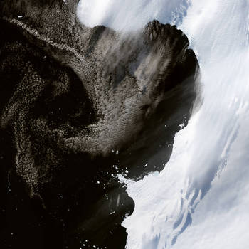
NASAの「今日の1枚」は、南極 の棚氷の写真です。
観測衛星のデータから、過去40年もの間にわたり、南極の棚氷が後退していることに、科学者たちは気付いていながら大局的視点に欠けていたと、NASAの記事としては珍しく批判調に伝えています。
40年間の違いの画像や記事について詳しくは:南極の氷に見る不都合な真実
オリジナル記事:
Pervasive Ice Retreat in West Antarctica
Along the Bellingshausen Sea coast of West Antarctica, ice has been retreating inland being lost to the sea. Scientists knew this, but they lacked a full picture of the scale. Now a team of researchers has compiled a Landsat-based data set and found that such losses have been going on for at least the past four decades.
Image Credit: NASA Earth Observatory images by Jesse Allen, using Landsat data from the U.S. Geological Survey
Caption: Laura Rocchio, Landsat Communication and Public Engagement Team
Last Updated: June 23, 2016
Editor: Sarah Loff
日本語訳:
南極西部の氷が示す好ましからざる後退
南極西部のベリングスハウゼン海沿岸に沿って、氷が内海に失われながら後退しています。科学者たちは、このことを知っていましたが、彼らは全体を俯瞰できる視点を欠いていました。今、研究チームは、ランドサットの観測データをもとに、このような事態が、少なくとも過去40年間続いてきていることを確認しました。
【意外と知らないIT用語】ドメインって何? お名前.com


スポンサーリンク
観測衛星のデータから、過去40年もの間にわたり、南極の棚氷が後退していることに、科学者たちは気付いていながら大局的視点に欠けていたと、NASAの記事としては珍しく批判調に伝えています。

40年間の違いの画像や記事について詳しくは:南極の氷に見る不都合な真実
オリジナル記事:
Pervasive Ice Retreat in West Antarctica
Along the Bellingshausen Sea coast of West Antarctica, ice has been retreating inland being lost to the sea. Scientists knew this, but they lacked a full picture of the scale. Now a team of researchers has compiled a Landsat-based data set and found that such losses have been going on for at least the past four decades.
Image Credit: NASA Earth Observatory images by Jesse Allen, using Landsat data from the U.S. Geological Survey
Caption: Laura Rocchio, Landsat Communication and Public Engagement Team
Last Updated: June 23, 2016
Editor: Sarah Loff
日本語訳:
南極西部の氷が示す好ましからざる後退
南極西部のベリングスハウゼン海沿岸に沿って、氷が内海に失われながら後退しています。科学者たちは、このことを知っていましたが、彼らは全体を俯瞰できる視点を欠いていました。今、研究チームは、ランドサットの観測データをもとに、このような事態が、少なくとも過去40年間続いてきていることを確認しました。
【意外と知らないIT用語】ドメインって何? お名前.com
スポンサーリンク


